Tuesday 13 October 2015

30th May, 2015 - Kingsdale and Gragareth

This is an account of a walk I did several months ago with Steve, one of my oldest friends, and it is a blog post which had slipped through the blogging net. When I say 'one of my oldest friends' I mean we have known each other for a long number of years, and not that he is getting on a bit and into his dotage. If I remember correctly, he is a couple of years younger than myself, although from looking at us you would think he was much, much older; he did have a difficult paper round as a kid, and it must be that which has taken it toll on him.

The aim of the walk was "to climb Lancashire's highest hill", which is now Gragareth at 2,057 feet, or  627m - seems simple enough doesn't it, but there was much agonising behind the scenes before we got to this point. By way of a bit of background history to this "Lancashire's highest hill" business, we have to glance at a bit of English Government gerrymandering that still causes people to sigh heavily to this day. Prior to the passing of the Local Government Act in 1972, and the resulting County Boundary changes that then took place in 1974, the highest hill in Lancashire was Conistons' "Old Man" at 2,634 feet high, or 803m, however since 1974 it was "moved" into Cumbria. Call me old fashioned if you will, but I just cannot bring myself to recognise the 'new' county boundary of Lancashire, and I still refer to Lancashire as being the old county Palatine boundary of Lancashire, or 'historic' Lancashire complete with its bits 'north of the sands'.

Furthermore, technically, where I live, now comes under 'Greater Manchester', which I find very odd as it is a County that has a boundary which is not shown on maps, has no county boundary signs at its borders and whose governing Council was abolished nearly thirty years ago in 1986. In fact, 'Greater Manchester' has been out of existence as a County for longer than it was actually in existence and yet people still refer to it as part of their address. How this state of affairs came about is even more puzzling as it was created purely as an administrative area and not a geographic replacement for Lancashire. "Greater Manchester" is a bastardised mongrel of a County in my opinion and the 'historic' Lancashire should never have been disposed of... Well, legally speaking it hasn't been disposed of as this statement clarifies...


"We confirm that although the changes brought about by the 1972, and indeed, subsequent legislation, have altered the administrative boundaries of the County (of Lancashire) for the purposes of local government, they have not affected the boundaries of the Palatinate." 
Duchy of Lancaster - 29th August 1996 

...and who is the Duke of Lancaster you may ask?.. For those in the dark on the answer to this, it is HM t'Queen, or Liz, as she is known in these parts. If the Queen says it is so, then I'll not doubt her, or off to the Tower it will be for me.

As both Steve and I are proud Lancastrians, being born the correct side of the boundary changes in the early 1970's it was difficult for us to reconcile, as technically, and according to my boundary belief system, we should be going up the Old Man of Coniston to get to Lancashires highest hill - however, as Steve said, we cannot live in the past and must change with the times, so for this walk Gragareth is the highest point in Lancashire, albeit only temporarily so in my mind and through gritted teeth. I digress with my rant, so back to the walk..


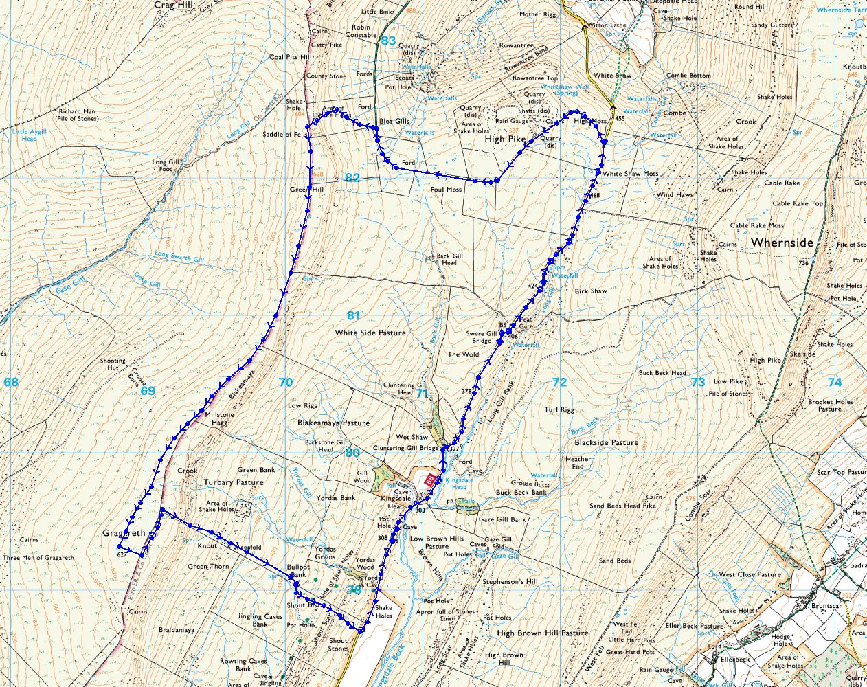
Distance - 7.9 miles
Ascent - 1,378 ft
Sandwiches - Cheese & Ham salad


Elevation Profile

OS Route Map
3D Image of route
I picked Steve up on the Saturday morning after making a huge pile of sandwiches to sustain us on the walk, and the weather forecast was going to be fine but overcast. Having looked at the maps the night before, I decided that the best route for us to get there was to drive up to Ingleton on the A65 and then take the minor road which leads up through Kingsdale. 

On the way up I was recalling that I had been up in this area the week previously to grab some photos, and that I had called into Ingleton and had a full breakfast at one of the two cafes in the centre. Now, this put an idea into Steve's head, and Steve being a chap who loves his food he made the robust suggestion that we should stop en-route and do the same again. I'm easily convinced, and as I had not eaten at all this morning I thought it would make sense to prevail on the hospitality of the Inglesport Cafe and partake in one of their 'All Day' offerings. So it was sausage, eggs & B all round, accompanied with tea and toast and all the other trimmings. We feasted on the comestibles placed in front of us and then sat there for quite a while looking like a couple of really contented Buddha's. We then decided to make a move or this walk wouldn't get completed. We slowly stood up, waddled down the stairs and out into the main street and back to the car to continue our journey.

Kingsdale is one of the lesser known Dales in Yorkshire and one of its valley sides is formed by the massive bulk of Whernside and the flanks of Gragareth comprise the opposite side. It is a place I had never visited before this walk and made a mental note to visit again at some point in the future and explore it further. It is long and largely uninhabited with a minor road running along its length and dropping down into Dentdale at its far end. There are only a couple of isolated farms on the valley floor in the dale and that is it. Trying to find the place was difficult though as there are no road signs saying "Kingsdale this way", we took a number of wrong turns up various dead end farm tracks and passed through several small hamlets prior to picking up the road through the dale at Thornton in Lonsdale.

We parked at the head of the valley at a place marked on the OS map as High Moss. This was where a junction was formed between a substantial bridleway and the minor tarmac road. As we got out of the car, the wind hit us. I had shorts on, as I usually do, but it still made me give a sharp intake of breath and I had to rummage for my Berghaus Paclite shell to give me a bit of wind proofing to my upper body. We changed footwear and hoisted our packs onto our backs and set off along a very well made bridleway. The bridleway made for good going and the gradient was gradual. We took this path as we could make good, easy progress then head up the flanks of Gragareth and walk along the summit ridge.

The bridleway ran straight and flat at an area shown as Foul Moss, and the view from here was excellent and very open. You could make out the bridleway snaking its way around the head of a small valley and along the flanks of Great Coum. This must have been a pack horse or drovers road at some point and is marked on the OS maps as "Green Lane (track)", it is also known locally as "Occupation Road" and thought to have been named from the time of the Enclosure Acts in the late 18th Century, although it has been suggested that the road may even be Roman in origin.


Bridleway at Foul Moss
Ingleborough from Foul Moss
Looking up to the Gragareth ridge from Foul Moss

As we crossed a small ford on the track leaving Foul Moss behind, the road surface changed dramatically from even, flat gravel to boulders and puddles. At some point in the last few years, the track had undergone some maintenance and was very good, up to this ford, and the track after this was just a morass of boulders, puddles and bog - perhaps it was where the money ran out. It was difficult going even on foot, never mind trying to get a train of loaded pack horses through here. As we rounded the bend in the track and approached Blea Gills we took a left turn and headed straight up the fell-side. As we left the track behind we could see a chap in the distance following the track and coming in the opposite direction to us, and he was pushing his mountain bike. He had clearly given up being able to ride the thing along the bridlepath and was using it as a true 'pushbike'. I really felt for him and his disappointment. This sudden uphill exertion came as a shock to the system I can tell you, as we had been making steady, easy progress along a reasonable track, and now with legs pistoning, heart pumping and lungs heaving we were climbing up the steep side of the ridge from Great Coum to Gragareth. Slowly, as both legs and lungs were giving out, we approached the top of the ridge and the view of Kingsdale below started to open up as we gained height and gave us the reward we needed.

North to Deepdale and Dentdale from above Blea Gills

We got to the summit of the ridge at a place shown on the map as "Saddle of Fells". We had a brief discussion here as to the choice of route. We could go around north to Great Coum and Crag Hill in order to 'bag' a couple more summits whilst we were up here, but that would have meant doubling back along the path we had just walked along to ultimately get to the object of the walk which was Gragareth. We quickly decided to head straight for Gragareth. At "Saddle of Fells" we turned and headed south, leaving Great Coum and Crag Hill for another day. 


The view to the Irish Sea from "Saddle of Fells"

As we left the "Saddle of Fells" behind and headed in the direction of Gragareth, we gained more height as we ambled towards Green Hill. Along the summit of this ridge is a large and substantially built drystone wall which forms the boundary between the two Counties of Lancashire and Yorkshire. Consider it as a sort of a mini Hadrian's Wall separating civilisation from the barbarian hoards. Which group is which is up to you to decide.

The top of this ridge is just barren hillside with the wind whipping straight across the summit from off the Irish Sea in the distance. As it is flat on the summit of the ridge, the vegetation just acts as a sponge and retains water, and although the weather had been good for a few weeks previous, the walking underfoot was very boggy indeed. The path followed the route of the boundary wall and to be honest with you, it turned into a bit of a trudge with much grumbling between the two of us. The distance from the "Saddle of Fells" to the summit trig point of Gragareth was two miles - it certainly didn't look two miles on the map, and at one point we were doubting ourselves and wondering if we had actually walked past the trig pillar as there are few identifying features up here.


The County boundary wall looking North

Eventually we found it. The summit trig pillar! Whilst not feeling as elated as Hillary and Tenzing were when they completed their famous summit climb, we were still happy to have come across it and realised we were the highest people in Lancashire at that time. The summit was deserted, and it didn't look as though many people actually bother to come up here, even though the views are terrific, but why should people come up here when they have X-factor and Strictly Come Dancing to provide entertainment? Bread and circuses in my view but let's not get onto that.


The highest point in Lancashire, the trig' pillar on Gragareth

Whilst up on the summit, I suggested that we go and have a look at the Three Men of Gragareth, which are some large stone cairns on the hillside around 100m down from the top. After a quick discussion, we concluded that they weren't on our route and added another 150m or so to our total ascent, so we decided to also leave them for another time too. 

Summit Panorama towards the Irish Sea
We took the quick way down and crossed the boundary wall over into Yorkshire with a descent into Kingsdale; I didn't have my 'papers' on me but the border guards were not to be seen - I think there was a game of cricket taking place somewhere so they were distracted. After crossing the wall and descending slightly, we decided to sit down and look at the view over to Ingleborough and have our sandwiches. The vista just dropped away into valley far below us and the dark bulk of Ingleborough with its distinctive silhouette was on the horizon and even further away the profile of Pendle Hill was also visible.


Pendle Hill on the horizon
We found a suitable rock to sit upon and Steve went at the sandwiches like a man possessed. He ate all his, and then had a try with a couple I was struggling with; he has a legendary appetite and I don't know where he puts it. Food finished, we reluctantly stood up, shouldered our rucksacks again and made our way down the steep escarpment that forms one of the sides of Kingsdale. We followed a drystone wall as we made our way down, and were surprised to see the angle of the ground on which it had been built. We struggled walking down it, and I certainly wouldn't have liked to carry stone up it to build a wall. We passed an area to our left marked on the map as Turbary Pasture, a name which I had seen previously in the Dales and after doing some reading later about the name, it denotes an area of land set aside for the cutting of peat. I have come across it a couple of times on other walks, and there are also Turbary Roads, which presumably lead to areas where the common folk could dig peat for use on domestic fires in the absence of using wood or coal for cooking.

Looking down into Kingsdale

Looking North, up to the head of Kingsdale
The photographs don't give the sense of scale of the drop of the escarpment, it felt like standing on the edge of the world as the moorland slipped away in front of you. There are very few trees, or other features in the dale and the long straight stonewalls make for excellent navigation. They are a testament to the skill of the men, long gone, who put them up without aid of the mechanical devices we now have, but just sheer graft and skill. I would have thought they would be proud that their work was still here, and standing after what must be a couple of hundred years in wind, rain and snow. Impressive monuments indeed, although very much anonymous.

Drystone wall in Kingsdale

The descent starting taking its toll on our knees, so we were pleased to see the road at the valley bottom. The ground was also rough underfoot and I had gone over on my ankle more than once. As we got onto the macadam surfaced road, it was a blessed relief to start making good progress and taking some long steady strides. We were soon picking up the pace and had soon got into a decent rhythm. 

We strolled past Yordas Cave, which was just off the road in a plantation of trees, and didn't really give it much attention, however we should have had a look as it used to be a 'show cave' and is quite impressive inside. Our loss! The sky was gradually darkening and time was getting on, and we both had the anticipation of settling back into the car and taking the weight of the legs. We walked for nearly an hour along the road back to the car, it was 2.6 miles in total and it seemed an absolute age. In all the time we were walking along the road not a single car passed us by, although Steve kept asking in a plaintive voice, "Are we nearly there yet?"

As we approached the car a great sense of relief came over us and Steve very nearly kissed it, such was his appreciation. It was wonderful to take the pack off, and it is surprising how heavy the camera and a couple of lenses can become after a time. After changing our footwear and settling into the front seats, we set off back, via Ingleton obviously, so Steve could then call at the chip shop for some food in order to sustain him until he got home and had his 'proper' tea. The tape worm must have been pressuring him.
All in all, a good day's walking, (and eating for some!) Kingsdale is worth another visit. If you want isolation then it is the place to be. In winter after a hard snow fall, you wouldn't see another person for days. I look forward to seeing it again.


Monday 21 September 2015

Sunday 13th September 2015 - A review of the GriSport "Peaklander" walking boot

This blog post is a departure from the normal type of blog in which I write about the walks I have been on and describe the route taken etc, and to further differentiate it from the ‘usual’ stuff it has the added benefit of video - did I hear someone at the back say Betamax?... or if getting down with the kids, it has a “vlog” (video blog) embedded in it. Progress eh?

As some of my readers will know I send out the occasional Tweet now and again to fill in the time between going out for walks and taking photos, and the other week I was quite surprised to be contacted on Twitter by @Grisport_UK, a manufacturer of walking boots. GriSport made the kind request of asking me to undertake a boot review for this very blog, to which I agreed. So, those kind folk up at GriSport sent me a pair of leather “Peaklander” walking boots which I then proceeded to try out. Now, this review is my own opinion of the boots, and everybody and his dog has an opinion, so should you feel inclined to disagree with what I’ve written then by all means do so, however, do note that I have tried to be objective and reasoned and to give a fair account of what I thought about them.


GriSport are an Italian footwear manufacturer who is based in the foot hills of the Dolomite Mountains – walking territory indeed! They were established in 1977 and have extensive research and development facilities, and through this have become a major supplier of footwear in Europe with a growing reputation for good quality, technical footwear and they have a very large range of walking boots available too. Their mission is “to provide the most comfortable footwear available”. I had heard of GriSport, and seen their boots in the shops, but I had never really paid much attention to them when I had been browsing the footwear sections of my local outdoors shop. Still, when a manufacturer contacts you and offers to send you a pair for review, you do tend to sit up and pay attention.

The Peaklander, fresh out of the box
After a brief discussion with GriSport, the boots I received were the “Peaklander” which is an 'oiled' leather (according to page 3 of the brochure), 3 season walking boot in my size of 45 (UK size 11). The boots are available in either brown or black and I received the brown ones. "Oiled" (possibly a mis-translation of waxed?) leather was not something I had really come across or considered before, but there was, or is, a slight oily feel to the surface, not that anything comes off on your hands or anything, so don’t hold that against them and after use it soon vanishes. The boots felt quite light, and I was surprised at this lack of weight when I took them out of the box. I got the scales out and they weighed in at 710g (1lb 9oz) each, which is less than my regular Berghaus Explorer Trek GTX’s which are 745g (1lb 10oz) each, and substantially less than my winter boots, the original Scarpa Manta M4’s at 1010g (2lb 3oz). The brochure gives a weight of 1120g, which I presume is for a pair, and even when halved to 560g for each boot is still way out from what my digital scales say. Perhaps the gravity is less in Northern Italy than it is in North West England, which would account for this discrepancy.

The boots look very attractive indeed (what did you expect? They’re Italian!), and are made from one piece leather. There is a line of triple stitching above the instep to join the uppers together. They are lined with a Spo-Tex waterproof and breathable liner, which I guess is GriSport's version of GoreTex™ and works just as it should. The sole is a “Track On” sole, which again is GriSport's own make, and is virtually the same in texture and hardness as the market leading Vibram sole. Grisport do use Vibram on some of their other boots, but not on this model. The sole has deep cleats and a varied tread pattern which should offer grip in all directions and the deep cleats are shaped so they don’t hold mud.

Get the “Peaklander” on your feet and they are very comfortable indeed. I strapped them on and then went up Pen Y Ghent. They were comfortable from the off. No breaking in needed at all and no hotspots either on my feet. The boot is snug, but not too tight, which should give good dexterity and stability when hopping from rock to grass across boggy moorland as your feet feel more in touch with what is happening around them. The footbed seems quite wide too, which suits me fine, but I will have to put a few more miles in to see how the boot handles longer distances. The heel and sole curve has a nice smooth rolling action, and the well-padded ankle cuff provides some stiffness, but allows some flexibility. The is quite stiff which will give good support on uphill stretches, and the torsional stiffness along the boot is really good. This should help prevent your ankle tiring when walking across an uphill slope. The boots have seven bronzed steel eyelets fixed to each side of the bellows tongue, and these have plenty of room in them for the lace to easily pass through, (unlike some recent approach type shoes I bought last year, no names disclosed but a well known manufacturer). The seven lace fixings comprise of four closed eyelets to each side, and three hooked ones, the first of the hooked eyelets has a self tensioning profile to it, to prevent to lace becoming loose when in use.

GriSport 'Peaklander' with Pen Y Ghent in background
The boots were used on various types of terrain; grass, limestone, up and down stiles, along tarmac and through a stream too – they performed very, very well, and were comfortable throughout. I have perhaps done about 6 miles in them so far and not a pinch or grumble from the ‘plates of meat’. I must admit to really liking these; however I will be doing quite a few more miles in them and posting up my findings in a month and in six months in order to give a more objective review over a great time scale.

The route taken up Pen Y Ghent was from Horton in Ribblesdale, and up the lane leading to Brackenbottom. This then took the main 3 Peaks Challenge route up the prow of Pen Y Ghent, following the Pennine Way. We camped over as we arrived on Saturday evening, and had chosen the same weekend as The Royal Signals has chosen for their Lanyard Trophy which took place on the Saturday. The campsite, which in my experience is usually sparsely populated had transformed into a military camp - however, they were very accommodating and managed to squeeze us into a corner with a few other civi's. The Lanyard Trophy is an inter-regimental challenge of differing regimental teams having to complete a 40 mile hike all with 40lb packs on their backs. Just thinking of this tires me out, but it would have been a good test of the GriSport boots. After chatting to one of the participants, he told us the winning team this year did it in just over 10 hours, and included the Three Peaks in it. The slowest team completed in just over 18 hours. 

We set out on Sunday morning, passed through Brackenbottom and started climbing the path to Pen Y Ghent, where we met with a constant stream of people coming in the opposite direction who were doing the 3 Peaks for a heart charity. I must admit to being taken aback by the number of people passing us. I have done the 3 Peaks about 6 times previously and the last time would have been in the mid 1990's (my personal best is just over 6 1/2 hours) but I don't remember it being like this - I've seen less people in Manchester city centre! We got to the Pennine Way and decided to turn around due to the numbers of people streaming off the summit - it would have been a battle just climbing up there against these numbers and a large number were carrying blow-up dolls; it seemed more of a stag party than a charity walk.

An old lime kiln below Pen Y Ghent

I'm all for raising money for charitable causes; I'm a trustee of a charity myself, but I must say that the numbers of people I experienced on this short stroll have really put me off going to any of the Yorkshire three peaks at any other time than Winter. Call me a whinger, but the numbers do seem to be out of control.

Anyway, we got back to Horton in Ribblesdale and then went to The Crown Hotel for some lunch, only to find that they had stopped serving food; however, to their credit, they did knock up several bowls of chips and some bread and butter - so it was chip butties all round! This surprised us because we have never been to a pub with so many notices pinned up telling us what not to do - you know the type "Don't do this, Don't do that, Don't do the other, No this, No that, No the other...." All on A4 paper and laminated too!


So far, so good then? What’s the downside? Well, erm, ummm, I can’t really think of one. The only thing that does spring to mind is that they look like they have seen more action than they actually have had. I think it is down to the oiled (waxed??) finish on the leather - any scuffs from climbing over walls and stiles etc show up a light brown scratches, and areas of greater wear and friction have become slightly lighter in colour too. I don’t doubt that this will disappear with a bit of boot care or surface treatment, and it doesn’t affect the performance of the boot in any way; it is just cosmetic, however it did surprise me when I took them off. I will report back on this in a few weeks, but my overall impression was one of a very well made, very comfortable walking boot, and one to look out for in the future.

Watch this space, as I'll update the blog in the coming months as I get more used to the boots.

Thanks for reading.


Sunday 17 May 2015

Friday, 15th May 2015 - A Circuit Around Malham


Dear readers, please forgive me for I have sinned... I haven't updated the blog for about three months. I have no excuses to offer. I haven't been ill. I have no other mitigating circumstances to lay before the jury - it is just that I haven't been out walking 'proper' in all that time. There has always been something to do at weekends which fills the time available and has prevented me from getting the boots on, and I'm quite certain you don't want to read in detail about me wandering around the local field for the umpteenth time during my lunch break and trying to clear my head. Nevertheless, several weeks ago, my neighbour David and myself agreed that we must get out on a walk prior to him jetting off on his holidays. Weeks went by and we hadn't arranged anything as both our work diaries clashed and kept clashing. Fortunately at the last minute we both had Friday free. After some last minute text messaging which sounds ridiculous as he only lives two doors away, we were 'on', and I promised to drive too, so it must have been that which ultimately persuaded him to come along.

We set off at 9:45am on the Friday morning and trundled over to Malham, or Malham Tarn to be precise. The journey took just over an hour, which isn't too bad going really. I'm certainly not a fast driver these days, and the Peugeot 205 GTI boy-racer of my youth has completely vanished - not a ghost of him to be seen anymore.

We pulled into the almost deserted car park near to the outfall for Malham Tarn, and in this exposed spot the wind certainly hit us as we opened the car doors to get out. The sun was shining so that was a bonus for the start. We put our boots on, arranged our rucksacks, zipped up our fleeces and locked the car to set off walking.

Distance: 7.5 mi
Ascent: 1330ft
Sandwiches: Bacon, Lettuce and Tomato / Corned Beef & Piccalilli


Route Profile
OS Route Map

3D Route Map

We went to the outfall of Malham Tarn first, known as Tarn Foot on the OS maps, just to have a look at the water. Malham Tarn house really did look small across the expanse of grey lake. David noticed a boat out on the Tarn with two fishermen in it. I have been to Malham Tarn a number of times, but have never seen anybody fishing there, so that was a first.

Malham Tarn and Tarn Foot

Malham Tarn Field Studies Centre

The current Tarn House was handed over to the National Trust in 1946 by the Morrison family who had built it in the Victorian era from the proceeds of their industrial empire. The National Trust then leased it to the Field Studies Council in 1947, and they have occupied it ever since. After lingering for a short time at Tarn Foot, we turned around 180 degrees and picked up the Pennine Way which would lead us down into Malham village. We crossed the unclassified tarmac road, and walked over the stream coming from the outlet of the Tarn and followed a signpost for the obvious path of the Pennine Way.

Do I need to caption this as "Pennine Way signpost"?
The walking along this part of the Way was wonderful; there was springy grass underfoot and it was flat and soft. In equestrian terms it would probably be noted as 'going: good to firm', not that anybody would be placing bets on us completing this circuit in a set time, although we hoped David's knee would hold out until the finish line - I didn't fancy shooting him on the final furlong due to a dicky leg.

Local resident... all say "Awwww!"

The Pennine way - Going: Good to Firm

We quickly progressed along our route and headed towards Ing Scar. The sun was shining and was warm to our faces and fluffy white clouds were scudding overhead and casting various shadows onto the surrounding hillsides. A great walking day. We were quite taken aback by the sudden drop at Ing Scar; I have been along here several times previously, but had forgotten about this deep cleft in the earth.

Unknown cave at Ing Scar (not marked on map anyway)

Ing Scar
We made our way round the head of Ing Scar, and climbed the wooden stile to take the rocky path down along the valley floor. The going along this path was poor underfoot and you did have to watch were you placed your feet due to the amount of rocks scattered about. The conversation was flowing as we ambled along, and we met a surprising high number of walkers coming the opposite way - It's Friday! Have they no jobs to go to?!

We walked beneath Raven Scar and came across the start of the limestone pavement that forms the top of Malham Cove. It was at this point that we thought it the ideal place to sit on the grass and partake of the comestibles tucked away in our rucksacks. We lay down on the grass in a sheltered spot in the sunshine and drank in the view... and what a view! 

Limestone pavement above the Cove

The view from the top

The view from the edge
We mixed and matched our sandwiches, and drank a bottle of Lucozade each, and both came to the conclusion it that tasted better in the old days when it was bought from dusty chemists' shops in a clear glass bottle wrapped in yellow cellophane - but only when you were ill. We lingered for about half an hour and watched a school teacher trying to wrangle a group of noisy teenagers across the top of the Cove - it was a close match in volume between the ravens and the teenagers. We finished off our lunch, reluctantly stood up, shouldered our packs and continued on our way. We picked our way over the clints and grikes, making sure we didn't lose our footing, although David's walking pole vanished a couple of times.

Looking along the top of the Cove
As we got to the edge of the limestone pavement we were met by a large group of middle aged ladies who sounded to be Scandinavian - it certainly wasn't English. David said they were French, but it didn't sound French to me; not that I was expecting them to sound like they had come from the set of "allo, 'allo", but French is quite easily distinguishable. A long way to come to see this impressive cliff, but maybe the Tour de Yorkshire had attracted them. Le Tyke Sportif!

We made our way down the well made steps at the side of the limestone cliff and met a large number of other walkers now coming up - it seemed as if we were going against the flow, and whilst we acknowledged the others coming up, not many had Yorkshire accents thus confirming that Malham is a tourist honeypot.

The steps down to the valley bottom and Malham Beck

We were on the right route!

We got to the bottom of the steps and David said he would like to see the base of the cove. We walked back towards the cliff and watched several climbers whilst they pitted themselves against the sheer limestone face. Whilst we stood and watched the climbers we realised were being 'buzzed' by a bat that must have been suffering from insomnia. I didn't realise they came out during the day. It was flitting about, as bats do, and really having a ball eating the insects that were near the surface of the water in Malham Beck and floating around the trees. The bat must have been about 12 inches away from us as it flew around our heads, and the description of it being akin to a mouse with wings seemed quite accurate. It was too fast and unpredictable for me to get a photograph. I wonder if it had been disturbed from its slumber by the climbers on the Cove? It certainly made a change from the wagtails and housemartins which were darting around in the valley.

Malham Cove, looking up

Climbers at play on the cliff face
We continued along the well made path which leads to the Cove and headed back towards Malham village taking in the views of the surrounding ancient field systems which were criss-crossed with drystone walls made from the limestone scattered in the fields. We also passed through a herd of very friendly young cattle - not sure what they were, but they had quite long hair and seemed amiable towards people.
Looking back to Malham Cove

Fields around Malham Cove... Grim up North? Yeah, whatever!

Limestone walls around Malham

Ancient looking barn at Town Head
We got to the start of the path leading to the Cove, an area known as Town Head. We followed Cove Road which lead us into the village. As we progressed, Malham Beck ran parallel to our left side, and I took the opportunity to have a sneak at the delightfully situated Beck Hall Hotel. It is approached over a stone clapper bridge that crosses Malham Beck and is a wonderfully romantic place to retreat to. I have stayed here previously, although it must be about twenty years ago now - hmmmm, I must be due for another visit soon.
Beck Hall Hotel, Malham
We continued past Beck Hall and along Cove Road, and just prior to getting to the road junction in the 'centre' of the village we turned left before the red telephone kiosk and adjacent a small wooded area, over another clapper bridge with an ornate wrought iron handrail, and strolled up to the Lister Arms. As the sun was shining it made sense to sit outside on the wooden tables. David very kindly went in and bought a couple of drinks, my choice was cider as the day was warm and I needed something light and refreshing. I really do like the Lister Arms as it is a Thwaites' pub which sells Lancashire ale in deepest Yorkshire!


Can you guess what I had to drink?

The Lister Arms, Malham
We drained our glasses and left the pub as the crowd of competitive road cyclists meeting up here got larger and louder, and walked down to the village shop in the centre. We crossed the little stone bridge adjacent the shop and after a quick discussion thought it rude to pass by the Buck Inn without stopping for a swift one. We sat outside, in the sun, watching the world go by, drinking our cold lager and eating our "Yorkshire" crisps - as the packet proudly proclaimed. Flat Cap and Whippet flavour I think.. although it didn't say as such on the packet. Whilst we sat watching the world go by, we did notice quite a large number of Belgian cars passing through the village, many had the sort of stickers on them you see on car rallies (the Monte Carlo rally etc) - maybe it was a Belgian car rally? Who knows, there was no-one to ask, and if I could my Belgian is really limited.

Road sign in the village centre

The village shop
We emptied our glasses again and departed the village along the Pennine Way. We turned left immediately after the village smithy to cross Malham Beck. Unfortunately the smithy was closed today, and we just walked past, but it is a wonderful place to get ornamental ironwork and other assorted bits of bespoke metalwork for house and garden, and mesmerising to watch the blacksmith hammering away in the forge. We crossed the stone bridge at the rear of the smithy and continued walking south along the Pennine Way. We pushed our way through another group of school kids and went through delightful meadows coming alive with wildflowers. We got to a dilapidated limestone barn, marked on the OS maps as 'Mires Barn', and took a left turn, thus leaving the Pennine Way behind for another day.

Mires Barn, Malham
We continued along the well made path past Mires Barn, and walked alongside the bubbling Goredale Beck. We continued with this flat, easy walking until we got to Mantley Field Laithe and then entered the deciduous woodland beyond.
  
Mantley Field Laithe
The sun was giving a dappled light through the trees, and the sides of the wood were heavy with wild garlic, the scent of which was wafting through the air. It was like being in a real life Consulate advert.. "..as cool as a mountain stream"

Wild garlic in the woodland
The walk through the wood was a pleasant change, and the path was well made and easy to navigate and gradually ascended the local topography. The valley sides started to get steeper and soon we were in a deep wooded valley. In the near distance we could see a magical waterfall illuminated by the sun which was shining through the trees. As we approached it we realised it was Janet's Foss.

Janet's Foss is a small waterfall formed by Goredale Beck falling over a limestone outcrop that is topped with tufa (a special type of porous limestone) into a deep pool below. Traditionally, the deep pool was used for washing sheep in summer. The name of Janet, (or Jennet), is a folk tale reference to a fairy queen said to inhabit a cave near the waterfall. Foss is a Scandinavian word for waterfall, and is still in use in Scandinavia, although the word appears in several places in England and gives a nod to the historic roots we share with the Viking invaders. It really is an enchanting place, and one can see how the association with fairies came about.

Janet's Foss

Janet's Foss - the deep pool
A small crowd had formed by the Foss so we decided to push on towards Goredale Scar. We climbed the steep, stone steps up to the tarmac road, crossed it and walked the short distance to the obvious deep ravine that is Goredale Scar. As we left the tarmac road, and walked along the gravel path, the campsite we passed through had started to get busier with weekend campers. We walked between the enclosing limestone cliffs and headed towards the waterfalls at the head of the ravine.

Goredale Scar from the campsite
The waterfalls at Goredale
Goredale Scar is thought to have been formed by a limestone cavern collapse thousands of years ago. The footpath that leads into the gorge goes straight up the waterfalls, and whilst it looks daunting it is an easy scramble with plenty of good foot and hand holds. The gorge is well known nationally, with William Wordsworth writing a sonnet about it, James Ward, painted it around 1815 which is considered a masterpiece of English romantic painting, and finally J.M.W. Turner painted it in 1816. Both his and Ward's paintings hang in the Tate in London, which is handy when you're in Yorkshire!


The path goes up from here...
After getting to the top of the short scramble, we made our way up the side of the ravine and onto the limestone plateau onto the high tops. The walking here was wonderful with big open skies that gave a complete contrast to the troglodytic experience of Goredale scar. The grass was soft underfoot again, the path was very clear, and the sun was still shining intermittently onto our faces. We made our way through the shattered limestone pavement and came across a solitary tree clinging onto the edge of the limestone. It was the only tree for miles around, and I was surprised to see it thriving as the area must be desolate in the depths of winter. 


Solitary tree
We continued past the solitary tree on the soft grass until we came to a set of stone steps over a drystone wall. We climbed these and walked along the tarmac surface of an unclassified road which took us back to the car on the small car park near Tarn Foot. As we took off our rucksacks, eased our bootlaces and climbed into the car, the rain which had looked distant a short while ago, now started splattering onto the windscreen. We could not have timed it any closer, just five minutes later and we would have been soaked to the skin.

It is usual practice to have a pint after a walk, but as there was no hostelry in the vicinity, apart from those at Malham which we had already visited, and it was now raining, we decided to make our way straight back home and have a celebratory pint in our village pub. So we started our journey home whilst discussing plans for our next outing when David has got back from his sunny sojourn abroad... watch this space as they say!